- How to read and give a map reference
- The 100km squares for Great Britain
- Giving a map reference
- Precision of map references
- Where map references are displayed on the MAGIC screen
- When you use map references
- How to form IACS compliant field numbers
- Coordinate Systems in MAGIC
How to read and give a map reference
The British National Grid enables a recognised reference to be given to any location in England, Scotland and Wales. Map references using the National Grid can consist of 2 letters followed by 2, 4, 6, 8 or more numbers, or can be given using numbers only. The more numbers used, the more precise the map reference is.
The letters refer to the 100km grid square the reference is within.
The first half of the numbers following the letter refer to the east/west position (called an easting), while the second set refers to the north/south position (called a northing).
The 100km squares for Great Britain
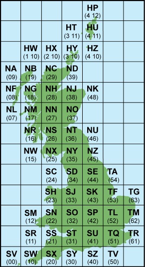
As the following grid squares: HP, HT, HU, HW, HX, HY and HZ are more than one thousand kilometres north of the grid's origin the numeric value of the square's second letter is represented by two digits. When creating numeric grid references for these squares the northing increases by one digit so HZ1234 becomes 412, 1034 and HP567123 becomes 456700, 1212300.
Giving a map reference
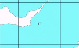
An example map reference ST391578 consists of 2 letters (ST) that identify the 100km grid square, 391 is the easting, and 578 is the northing. This map reference is precise to the nearest 100 metres.
The 100km grid square ST is shown below.
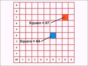
Each 100km square is then broken into 100 10km squares and referenced by the easting first, then the northing. The two squares on the diagram shown below would be referenced as ST64 and ST87 respectively.
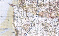
So the 10km square for our grid reference ST391578 is referenced as ST35:
And the 1km square is referenced as ST3957:
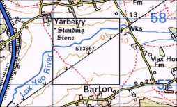
Our grid reference ST391578 can be used to locate Yarberry Standing Stones.
Alternatively you can used the full numeric grid reference by substituting 3 and 1 for ST as shown in the following table.
Precision of map references
| Number and Letters | Numbers only | Precision |
|---|---|---|
| ST | 31 | 100km |
| ST35 | 33 15 | 10km |
| ST3957 | 339 157 | 1km |
| ST391578 | 3391 1578 | 100 metres |
| ST39155785 | 33915 15785 | 10 metres |
| ST3915157851 | 339151 157851 | 1 metre |
Where map references are displayed in MAGIC
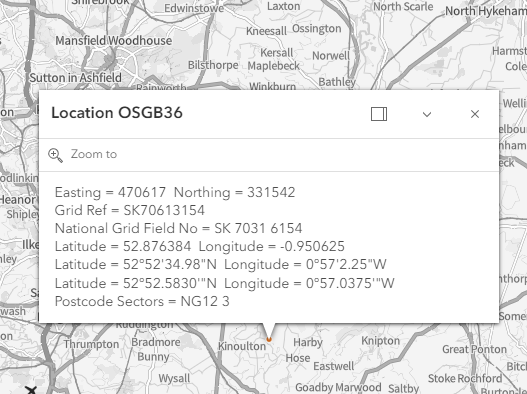
Map references are normally displayed in the status bar at the bottom of the map window when the cursor is hovering over a point on the map:
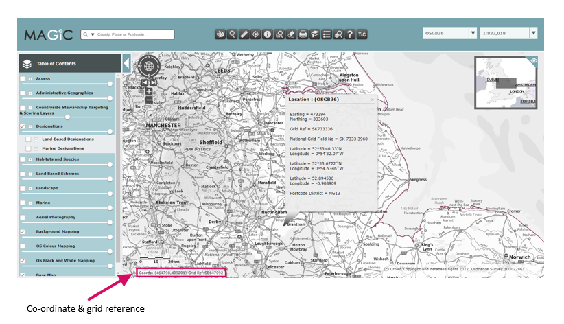
They are also displayed after clicking the 'Where am I?' tool ![]() then clicking on the map on the point you want the grid reference for:
then clicking on the map on the point you want the grid reference for:
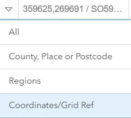
When you use map references
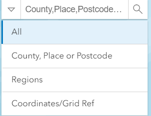
You can use map references in the search bar on the map page. You will firstly need to select the correct search criteria (Coordinates/Positions) by clicking on the map search bar arrow:

How to form IACS compliant field numbers
While MAGIC does not store IACS data, IACS compliant field numbers can now be viewed using the Where am I? ![]() tool in the interactive map – see the help library for details of how this tool works. Go to the IACS Compliant Field Numbers page for further information on how IACS field numbers are formed.
tool in the interactive map – see the help library for details of how this tool works. Go to the IACS Compliant Field Numbers page for further information on how IACS field numbers are formed.
Coordinate Systems in MAGIC
The online mapping resource of MAGIC uses the British National Grid (BNG) coordinate system as the main method of display of geospatial features. It also allows users to view the maps in a different projection as some datasets are visualised in other coordinate systems. These projections are computed on the fly for the user and are not permanent transformations. Besides the British National Grid MAGIC allows visualisations using WGS84 and ETRS89 projections.
Anytime coordinate parameters are changed into different projections there is a degree of transformation inaccuracies to be mindful of. The amount of distortion and inaccuracy depends on the incoming and outgoing coordinate projection and transformation parameters.
The thought to keep in mind about coordinates in MAGIC is that although the underlying GIS dataset coordinate precisions are accurate to the level of original capture by the data owner/publisher of specific layers, the presentation within MAGIC is for general map visualisation and not for precise Survey Level accuracy of features. Having said that the datasets in MAGIC are referenced to the accuracy level inherent in Ordnance Survey datasets such as VML/VMD Rasters and MasterMap etc.
Specific Scale thresholds are used within MAGIC to ensure features are only seen at scales suitable for visualisation of the layer. This requires users to navigate the map tools to zoom in to scale levels appropriate for the chosen layers to view.
In the past users have tried to get precise measurements of their boundaries, or point locations using MAGIC web maps as an accuracy reference, and comparing their own findings using smart phone GPS or other handheld devices and noticing differences. Below are some examples that can potentially lead to confusing conclusions.
Using the coordinate search field:
In the case of a user typing in coordinates in the location search text box, if Lat/Long is supplied (instead of Eastings and Northings), the coordinate transformation may not be suitable enough to pinpoint exact location as it must project the Lat/Long (WGS1984) to British National Grid assuming a national transformation default. This is a subject to accuracy issues with respect to projection transformation choices or defaults used. There are various transformation schemes that should be used depending on your regional location in the UK. The search field uses a default projection transformation where it might not reflect good accuracy depending on the user location in UK.
Smart Devices and Global Online maps:
Some users have used built in GPS in smart phones and some tables or other handheld devices and then proceeded to compare their results with Google Maps, ArcGIS Online and/or MAGIC. The results are going to show some differences. Google and ArcGIS Online are in a global Web Mercator projection, MAGIC is BNG. There will be some visible differences, albeit minor, that are naturally derived from using different projection systems.
Using smart phones for exacting GPS locations is never going to be fully accurate. It depends on interference and calibration of the device internal GPS. Calculating a location using smart phones is dependent on having triangulations that have dependencies on GPS satellite signal lock and availability of 3G/4G or Wireless signal to compensate for lack of locking with available GPS satellite. Inherently, it is recommended that users do not use web maps to create precision boundaries. It is okay to do so with the understanding that it may not reflect “survey level” accuracy as it is being digitised from a screen image whose clarity can be affected by the pixel quality of the monitor in use, as well as the zoom in scale factor.
If a precise property or field boundary is required, it is recommended that field grade survey equipment be used such as differential GPS, handheld (but calibrated) GPS.
Below are the Projections used in MAGIC:
| British National Grid |
|---|
|
PROJCS["OSGB 1936 / British National Grid", GEOGCS["OSGB 1936", DATUM["OSGB_1936", SPHEROID["Airy 1830",6377563.396,299.3249646, AUTHORITY["EPSG","7001"]], AUTHORITY["EPSG","6277"]], PRIMEM["Greenwich",0, AUTHORITY["EPSG","8901"]], UNIT["degree",0.01745329251994328, AUTHORITY["EPSG","9122"]], AUTHORITY["EPSG","4277"]], UNIT["metre",1, AUTHORITY["EPSG","9001"]], PROJECTION["Transverse_Mercator"], PARAMETER["latitude_of_origin",49], PARAMETER["central_meridian",-2], PARAMETER["scale_factor",0.9996012717], PARAMETER["false_easting",400000], PARAMETER["false_northing",-100000], AUTHORITY["EPSG","27700"], AXIS["Easting",EAST], AXIS["Northing",NORTH]] |
| ETRS89 |
|---|
|
PROJCS["ETRS89 / ETRS-LAEA", GEOGCS["ETRS89", DATUM["European_Terrestrial_Reference_System_1989", SPHEROID["GRS 1980",6378137,298.257222101, AUTHORITY["EPSG","7019"]], AUTHORITY["EPSG","6258"]], PRIMEM["Greenwich",0, AUTHORITY["EPSG","8901"]], UNIT["degree",0.01745329251994328, AUTHORITY["EPSG","9122"]], AUTHORITY["EPSG","4258"]], UNIT["metre",1, AUTHORITY["EPSG","9001"]], PROJECTION["Lambert_Azimuthal_Equal_Area"], PARAMETER["latitude_of_center",52], PARAMETER["longitude_of_center",10], PARAMETER["false_easting",4321000], PARAMETER["false_northing",3210000], AUTHORITY["EPSG","3035"], AXIS["X",EAST], AXIS["Y",NORTH]] |
| WGS84 |
|---|
|
GEOGCS["WGS 84", DATUM["WGS_1984", SPHEROID["WGS 84",6378137,298.257223563, AUTHORITY["EPSG","7030"]], AUTHORITY["EPSG","6326"]], PRIMEM["Greenwich",0, AUTHORITY["EPSG","8901"]], UNIT["degree",0.01745329251994328, AUTHORITY["EPSG","9122"]], AUTHORITY["EPSG","4326"]], |